Archivi:Crete topographic map-it.svg

Fail orginal (archivi in formad SVG, grandezza nominal 3 370 × 1 600 picsel, grandezza de l'archivi: 2,6 MByte)
Somari
| Descrizzion | |
| Data | |
| Sorgent |
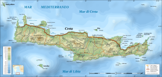
Own work ; Topography : NASA Shuttle Radar Topography Mission (SRTM3 v.2) data (public domain) edited with 3DEM and dlgv32 Pro and vectorized with Inkscape ; UTM projection ; WGS84 datum ; shaded relief (composite image of N-W, W and N lightning positions) ; Bathymetry : USGS ETOPO2v2 ; References used for the additional data : * Demis (see the approval e-mail and the Demis forum) ; * ViaMichelin ; * Map from Castello Hotels.com ; Locator map : Image:Map_Greece_expansion_1832-1947-fr.svg (modified) created by Historicair ; Translation of the Greek names into French : fr:Cédric Boissière and fr:Aeleftherios ; Approximate scales : * Topographic data and shore / lakes limits : 1:400,000 (accuracy : about 100 m) ; * Bathymetry : 1:14,800,000 (accuracy : about 3,700 m) ; Note : The shaded relief is a raster image embedded in the SVG file. |
| Autor | Eric Gaba (Sting) |
| Permess (Doperà ancamò quell fail chì) |
Attribution and Share-Alike required |
| Alter version |
[]
|


| Posission de la màchina fotogràfega | | La posission de sta qua e de altre imagini su: OpenStreetMap |
|---|

|
Custa figura SVG conten-e dël test ch'a l'é fàcil da tradui an la toa lenga, eventualment cun [toolforge:svgtranslate/File:Crete_topographic_map-it.svglink custo strument automàtich sì]. Pì informassion (an italian). |
Licenza

|
A l'è permess de copià, spantega e/o portagh di cambiament a quell document chì conforma ai termin de la GNU Free Documentation License, Version 1.2 o i so version vegnud adrée missa foeura de la Free Software Foundation; con tucce i sezzion che poden vesser soggette a di cambiament, senza de test de covertina e senza de test de retrocovertina . Una copia de la licenza è dent in la sezion che 'l so titol a l'èTest de la GNU Free Documentation License. |
- Te see liber:
- de spartì con di alter persone – de copià, mandà in gir e trasmeter el lavorà
- de organizzà de noeuv – de adatà el lavorà
- Sota 'sti condizzion chì:
- atribuzzion –
Te gh'hee de fornì i sgiust credit, un conligament a la licenza e insegnà semai che ghe sien stad portad di cambiament. Te podet fall in una quaisevoeur manera rasgionevol, ma minga d'ona manera che la sugerissa che l'autor approva ti o la toa utilizazzion.
- spartiss con di alter persone a l'istessa manera. – Se ti te mett insema messedand, te transformet, o te scrivet sgiò el material, te gh'hee de mandà in gir i tò contribuzzion sota la same or compatible licens come l'original.
Cronologia de l'archivi
Schiscia in su un grup data/ora per vedè l'archivi com 'a l'è che l'era in quell moment là
| Data/Ora | Miniadura | Grandezza | Utent | Coment | |
|---|---|---|---|---|---|
| corent | 13:15, 3 Mrz 2009 | | 3 370 × 1 600 (2,6 MByte) | Kanchelskis | == Summary == {{Location|35|20|00|N|25|00|00|E|scale:2000000}} <br/> Translation of below: {{Information |Description={{en|Topographic map in Italian of Crete island, Greece.}} {{fr|Carte topographique en italienne de l'île |
Ligámm
Quell fail chì l'è doprad de la pagina chichinscì:
Utilizazzion global di fail
Anca questi Wiki chì a dopren quell fail chì:
- Doperad in it.wikipedia.org
- Doperad in uk.wikipedia.org