Archivi:Map of Ancient Rome 271 AD.svg

Fail orginal (archivi in formad SVG, grandezza nominal 2 050 × 1 213 picsel, grandezza de l'archivi: 207 KByte)
Somari
| Descrizzion |
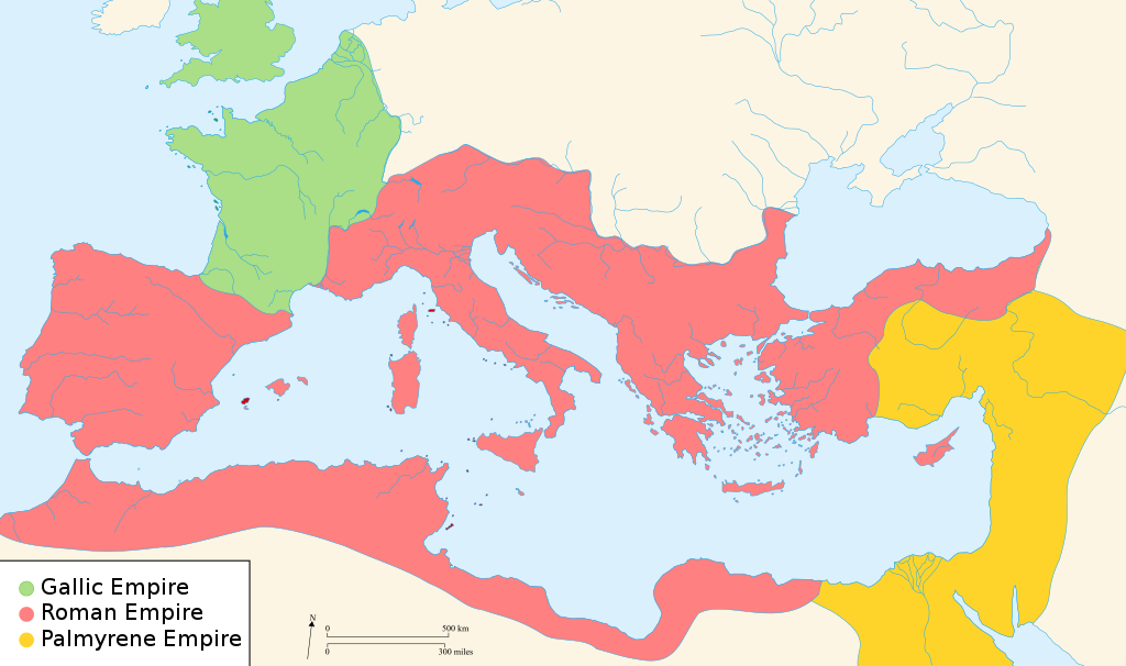
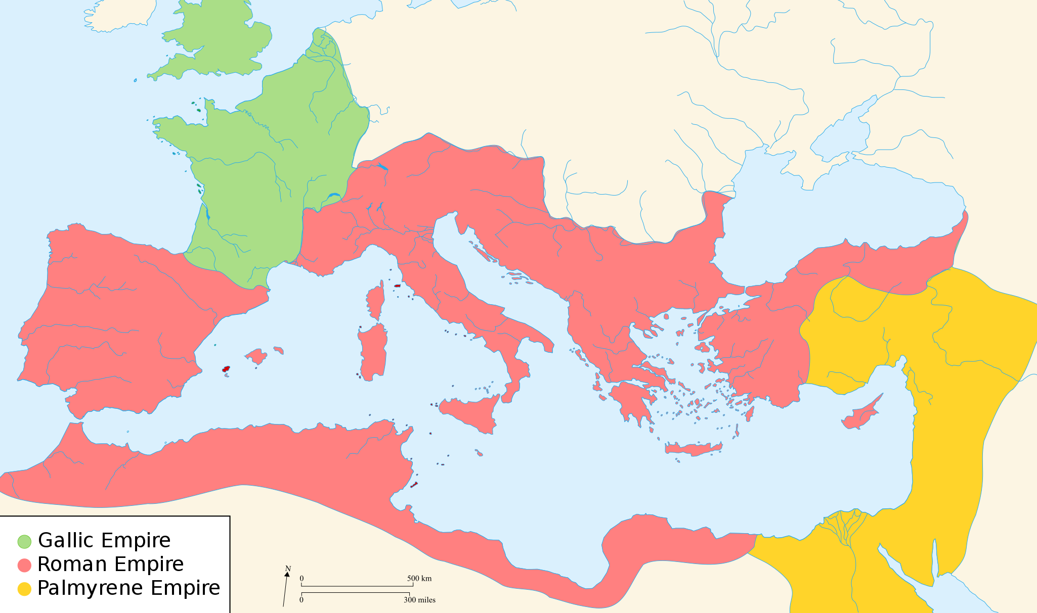
English: Map of the Roman Empire around the year of the consulship of Aurelianus and Bassus (271 AD), with the break away Gallic Empire in the West and the Palmyrene Empire in the East. |
||
| Data | (UTC) | ||
| Sorgent | |||
| Autor |
|
||
| Permess (Doperà ancamò quell fail chì) |
Mi, titolar del dirit d'autor, deciari de publicala sota queste licenze chìː
Quell fail chì l'è concedud sota i licenza Creative Commons Attribution-Share Alike 2.5 Generic, 2.0 Generic e 1.0 Generic.
Te gh'hee de fornì i sgiust credit, un conligament a la licenza e insegnà semai che ghe sien stad portad di cambiament. Te podet fall in una quaisevoeur manera rasgionevol, ma minga d'ona manera che la sugerissa che l'autor approva ti o la toa utilizazzion.
Te podet catà foeura la licenza che te voeuret |
||
| Alter version |
[]
|


.svg)


|
Custa figura SVG conten-e dël test ch'a l'é fàcil da tradui an la toa lenga, eventualment cun [toolforge:svgtranslate/File:Map_of_Ancient_Rome_271_AD.svglink custo strument automàtich sì]. Pì informassion (an italian). |
Licenza

|
A l'è permess de copià, spantega e/o portagh di cambiament a quell document chì conforma ai termin de la GNU Free Documentation License, Version 1.2 o i so version vegnud adrée missa foeura de la Free Software Foundation; con tucce i sezzion che poden vesser soggette a di cambiament, senza de test de covertina e senza de test de retrocovertina . Una copia de la licenza è dent in la sezion che 'l so titol a l'èTest de la GNU Free Documentation License. Soggetto a disclaimer. |
Register original del caregament
- 2007-11-07 02:47 Justinian43 524×377×8 (26490 bytes) The Mediterranean by 271 A.D -The [[Roman Empire]]. -The breakaway [[Gallic Empire]]. -The breakaway [[Palmyrene Empire]].
- derivative work: Pomalee (talk)
other_versions=Opere derivate da questo file: Map of Ancient Rome 271 AD-sr.svg Permission= GNU Free Documentation License, Version 1.2, Creative Commons Attribution-ShareAlike license versions 3.0, 2.5, 2.0, and 1.0
- Romanworld271AD.jpg: User:Justinian43, uploaded by User:El_bes
| Sta qua la xe na imagine ritocà, che vol dir che la xe stà modificà digitalmente rispeto a la so version original. Modifiche: Used "Blank_map_of_South_Europe_and_North_Africa.svg" to refashion "Romanworld271.jpg". L'original el se pol védar qua: Romanworld271AD.jpg. Modifiche fate da Pamela Butler.
|

|
A l'è permess de copià, spantega e/o portagh di cambiament a quell document chì conforma ai termin de la GNU Free Documentation License, Version 1.2 o i so version vegnud adrée missa foeura de la Free Software Foundation; con tucce i sezzion che poden vesser soggette a di cambiament, senza de test de covertina e senza de test de retrocovertina . Una copia de la licenza è dent in la sezion che 'l so titol a l'èTest de la GNU Free Documentation License. |
| Quell fail chì l'è concedud in licenza sota la licenza Creative Commons Attribution-Share Alike 3.0 Unported | ||
Te gh'hee de fornì i sgiust credit, un conligament a la licenza e insegnà semai che ghe sien stad portad di cambiament. Te podet fall in una quaisevoeur manera rasgionevol, ma minga d'ona manera che la sugerissa che l'autor approva ti o la toa utilizazzion.
| ||
| Quest'eticheta chì, sora 'ldirit d'autor, l'è stada sgiontada a quell fail chì come part de l'atualizazzion de la licenza di proget Wikimedia. |
Register original del caregament
This image is a derivative work of the following images:
- File:Blank_map_of_South_Europe_and_North_Africa.svg licensed with Cc-by-sa-2.5,2.0,1.0, GFDL
- 2007-08-09T20:26:49Z Historicair 2050x1213 (1260388 Bytes)
- 2007-08-09T16:12:00Z Historicair 2050x1213 (351130 Bytes) {{Improving}} {{Information |Description={{fr}}Carte vierge de l'Europe du Sud et du Bassin Méditerranée dans l'Antiquité {{en}}Blank map of South Europe and North Africa at Antic period |Source=Own work + [[Image:Blank map of South Europe and North Africa.svg]] by myself
- File:Romanworld271AD.jpg licensed with GFDL-en
- 2007-11-20T15:23:56Z El bes 524x377 (26490 Bytes) {{Information |Description= The Roman Empire around the year 271 AD, with the break awai Gallic Empire in the West |Source= http://en.wikipedia.org/wiki/Image:Romanworld271AD.JPG |Date= November 20th, 2007 |Author= [[http://e
Uploaded with derivativeFX
Cronologia de l'archivi
Schiscia in su un grup data/ora per vedè l'archivi com 'a l'è che l'era in quell moment là
| Data/Ora | Miniadura | Grandezza | Utent | Coment | |
|---|---|---|---|---|---|
| corent | 23:07, 20 Mrz 2022 | | 2 050 × 1 213 (207 KByte) | Leptictidium | File uploaded using svgtranslate tool (https://svgtranslate.toolforge.org/). Added translation for ca. |
| 07:06, 24 avo 2018 |  | 2 050 × 1 213 (207 KByte) | Ras67 | frame removed | |
| 17:14, 18 des 2011 |  | 2 050 × 1 213 (385 KByte) | Wanwa | more pleasant for eyesight colors | |
| 23:39, 27 avo 2010 |  | 2 050 × 1 213 (384 KByte) | Cplakidas | Corrections: the Agri Decumates beyond the Rhine had been abandoned already in 263, the Provence and Spain had been recovered by Rome in 269, and in 271, Zenobia controlled Asia Minor as far as Ancara at least | |
| 07:30, 26 feb 2009 |  | 2 050 × 1 213 (396 KByte) | Pomalee | Removed text labels from their paths and created a key. | |
| 06:36, 26 feb 2009 |  | 2 050 × 1 213 (393 KByte) | Pomalee | Changed the "Palmyran" label to "Palmyrene" | |
| 06:15, 26 feb 2009 |  | 2 050 × 1 213 (393 KByte) | Pomalee | {{Information |Description={{en}}Map of the Roman Empire around the year 271 AD, with the break away Gallic Empire in the West and the Palmyric Empire in the East. |Source=*File:Map_of_the_Ancient_Rome_at_Caesar_time-fr.svg *[[:File:Romanworld271AD. |
Ligámm
Quell fail chì l'è doprad de la pagina chichinscì:
Utilizazzion global di fail
Anca questi Wiki chì a dopren quell fail chì:
- Doperad in af.wikipedia.org
- Doperad in als.wikipedia.org
- Doperad in ar.wikipedia.org
- Doperad in azb.wikipedia.org
- Doperad in az.wikipedia.org
- Doperad in be-tarask.wikipedia.org
- Doperad in be.wikipedia.org
- Doperad in ca.wikipedia.org
- Doperad in cs.wikipedia.org
- Doperad in cy.wikipedia.org
- Doperad in de.wikipedia.org
- Doperad in el.wikipedia.org
- Doperad in en.wikipedia.org
- 271
- Aurelian
- Claudius Gothicus
- Crisis of the Third Century
- Outline of ancient Rome
- Western Roman Empire
- Tetricus I
- Ancient Rome
- Late Latin
- Fall of the Western Roman Empire
- List of revolutions and rebellions
- Ledringhem
- List of Roman external wars and battles
- User:ChazCAESAR/sandbox
- User:Kazkaskazkasako/Books/History
- Classical Anatolia
Varda utilizazzion global de quell fail chì.