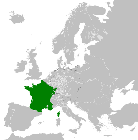
Archivi:Kingdom of France (1789).svg

Grandezza de quetsa presualizzazion PNG per quell fail SVG chì: 450 × 456 picsel. Alter risoluzzion: 237 × 240 picsel | 474 × 480 picsel | 758 × 768 picsel | 1 011 × 1 024 picsel | 2 021 × 2 048 picsel.
Fail orginal (archivi in formad SVG, grandezza nominal 450 × 456 picsel, grandezza de l'archivi: 911 KByte)
Somari


.svg)
.svg)
.svg)
.svg)
.svg)


.svg)
.svg)
.svg)


.png)
.png)


.svg)


.svg)

.svg)


.svg)
.svg)
.svg)
.svg)


.svg)
.png)


.svg)


.svg)
.svg)


.svg)


.svg)


.svg)
.svg)
.svg)
.svg)
.svg)
.svg)
.svg)
.svg)
_cropped.svg)
.svg)
.svg)
.svg)
.svg)
.svg)
.svg)
.svg)
.svg)
.svg)
.svg)
.svg)
.svg)
.svg)
.svg)
.svg)
.svg)
.svg)
.svg)
.svg)
.svg)
.svg)
.svg)
.svg)
.svg)
.svg)
.svg)
.svg)
.svg)
.svg)
.svg)
.svg)
.svg)
.svg)
.svg)
.svg)
.svg)
.svg)
.svg)
.svg)
.svg)
.svg)
.svg)
.svg)
.svg)
.svg)
Cronologia de l'archivi
Schiscia in su un grup data/ora per vedè l'archivi com 'a l'è che l'era in quell moment là
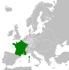
| Data/Ora | Miniadura | Grandezza | Utent | Coment | |
|---|---|---|---|---|---|
| corent | 10:12, 17 oto 2021 | | 450 × 456 (911 KByte) | Fenn-O-maniC | Fixed the Russo-Swedish border to match the Treaty of Åbo of 1743 |
| 08:36, 29 des 2017 |  | 450 × 456 (914 KByte) | TRAJAN 117 | Update | |
| 03:55, 25 des 2017 |  | 450 × 456 (832 KByte) | TRAJAN 117 | +++ | |
| 04:14, 27 avo 2013 |  | 450 × 456 (802 KByte) | TRAJAN 117 | +++ | |
| 23:52, 7 masg 2013 |  | 450 × 456 (839 KByte) | TRAJAN 117 | {{Information |Description ={{en|1=The Kingdom of France in 1789.}} |Source ={{own}} {{AttribSVG|Europe 1789.svg|Alphathon}} |Author =TRAJAN 117 {{created with Inkscape}} |Date =2013-05-07 |Permission ... |
Ligámm
Quell fail chì l'è doprad de la pagina chichinscì:
Utilizazzion global di fail
Anca questi Wiki chì a dopren quell fail chì:
- Doperad in ar.wikipedia.org
- Doperad in arz.wikipedia.org
- Doperad in ast.wikipedia.org
- Doperad in az.wikipedia.org
- Doperad in be.wikipedia.org
- Doperad in bg.wikipedia.org
- Doperad in cs.wikipedia.org
- Doperad in da.wikipedia.org
- Doperad in de.wikipedia.org
- Doperad in el.wikipedia.org
- Doperad in en.wikipedia.org
- Doperad in es.wikipedia.org
- Doperad in fa.wikipedia.org
- Doperad in fi.wikipedia.org
- Doperad in fr.wikipedia.org
- Doperad in ga.wikipedia.org
- Doperad in gl.wikipedia.org
- Doperad in he.wikipedia.org
- Doperad in hr.wikipedia.org
- Doperad in hu.wikipedia.org
- Doperad in id.wikipedia.org
- Doperad in incubator.wikimedia.org
- Doperad in is.wikipedia.org
- Doperad in it.wikipedia.org
- Doperad in ja.wikipedia.org
- Doperad in ka.wikipedia.org
- Doperad in ko.wikipedia.org
- Doperad in lfn.wikipedia.org
- Doperad in lt.wikipedia.org
- Doperad in lv.wikipedia.org
- Doperad in ms.wikipedia.org
- Doperad in no.wikipedia.org
- Doperad in nrm.wikipedia.org
Varda utilizazzion global de quell fail chì.
.svg)
.svg)