Archivi:UK motorway map - M67.png
UK_motorway_map_-_M67.png (250 × 200 picsel, dimension : 28 KByte, sort MIME: image/png)
Somari
| Descrizione |
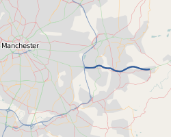
The M67 within the Manchester urban area. This map was created from OpenStreetMap project data, collected by the community. This map may be incomplete, and may contain errors. Don't rely solely on it for navigation. |
|||
| Data | (see file history) | |||
| Sorgent | openstreetmap.org | |||
| Creador |
OpenStreetMap contributors |
|||
| Permess (Doperà ancamò quell fail chì) |
OpenStreetMap data is available under the Open Database License (details). Standard style map tiles are licensed as ODbL Produced Works.
|
|||
| Georeferencing | If inappropriate please set warp_status = skip to hide. |
Licenza
- Te see liber:
- de spartì con di alter persone – de copià, mandà in gir e trasmeter el lavorà
- de organizzà de noeuv – de adatà el lavorà
- Sota 'sti condizzion chì:
- atribuzzion –
Te gh'hee de fornì i sgiust credit, un conligament a la licenza e insegnà semai che ghe sien stad portad di cambiament. Te podet fall in una quaisevoeur manera rasgionevol, ma minga d'ona manera che la sugerissa che l'autor approva ti o la toa utilizazzion.
Cronologia de l'archivi
Schiscia in su un grup data/ora per vedè l'archivi com 'a l'è che l'era in quell moment là
| Data/Ora | Miniadura | Grandezza | Utent | Coment | |
|---|---|---|---|---|---|
| corent | 22:04, 11 Mrz 2014 | | 250 × 200 (28 KByte) | Rcsprinter123 | update |
| 18:48, 18 gen 2013 |  | 474 × 599 (78 KByte) | Rcsprinter123 | small m67 highlighted | |
| 19:50, 15 feb 2011 |  | 790 × 998 (112 KByte) | Rcsprinter123 | {{Information |Description ={{en|1=A map of the United Kingdom's motorways, this shows the M67 highlighted in darker blue.}} |Source ={{own}} |Author =Rcsprinter123 |Date =2011-02-15 |Permission = |o |
Ligámm
Quell fail chì l'è doprad de la pagina chichinscì:
Utilizazzion global di fail
Anca questi Wiki chì a dopren quell fail chì:
- Doperad in cs.wikipedia.org
- Doperad in de.wikipedia.org
- Doperad in fa.wikipedia.org
- Doperad in nl.wikipedia.org
- Doperad in simple.wikipedia.org
- Doperad in www.wikidata.org